


Possible Prehistoric Circle Detected Under Peat on Scotland’s Isle of Arran
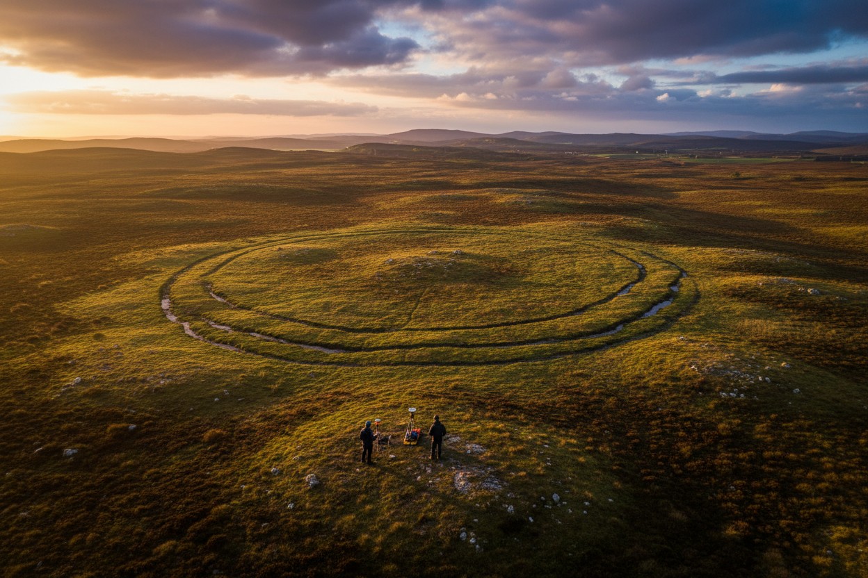
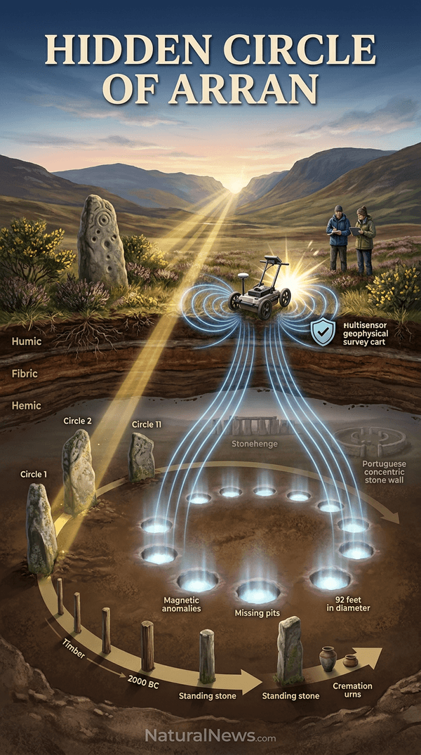
Archaeologists using geophysical survey equipment have detected a ring of magnetic anomalies beneath peat at Machrie Moor on Scotland’s Isle of Arran, according to Historic Environment Scotland. The feature consists of 12 pit-like anomalies arranged in a circle approximately 92 feet across, with two gaps that could represent the locations of two additional pits, suggesting the monument may have originally contained 14 posts or standing stones.
Historic Environment Scotland announced the discovery on June 30, with senior heritage recording manager Nick Hannon stating it “completely surpassed our expectations,” according to the agency’s statement. The circle has not been excavated, and researchers noted no indication of stone within the anomalies, leaving open the possibility of a timber circle later replaced by stones.
Machrie Moor’s Prehistoric Landscape and Known Circles
Machrie Moor is a well-preserved ritual landscape with six previously known stone circles and ceremonial sites dating between approximately 3500 and 1500 B.C., according to the survey report. The circles align with a notch at the head of Machrie Glen where the midsummer sun would have risen, suggesting astronomical orientation played a role in their placement. This alignment echoes findings at other Neolithic and Bronze Age monuments across Britain, where geometric and astronomical precision has been documented, as noted by researchers studying ancient sacred geometry [1].
Earlier excavations at Machrie Moor Circle 11, dated to the Bronze Age, revealed that some circles originally held timber posts later replaced with stones, and human cremations were added over time, indicating changing ceremonial functions. The broader tradition of circular monuments is well known from sites such as Stonehenge, where the builders employed sophisticated measurements and alignments [2] [2].
Details of the Newly Discovered Anomaly
The anomalies were identified during a survey designed to test how modern geophysical instruments performed on peat-covered terrain, according to Historic Environment Scotland. The 12 circular anomalies are spaced about 21 feet apart, with two wider gaps that the researchers said could indicate the locations of decayed pits. “There is no indication that any of these anomalies contain a stone” at this time, the researchers noted in the report, so the circle could have been built from either timber posts or standing stones that were later removed.
Representatives of Historic Environment Scotland stated that the feature likely dates from a similar period as the other standing circles at Machrie Moor, though no excavation has been conducted to confirm this. The survey report emphasized that the anomalies are magnetic disturbances in the soil that often indicate archaeological features such as pits or postholes.
Context Within Broader Prehistoric Monument Traditions
The possible circle adds to hundreds of Neolithic and Bronze Age timber and stone circles built across Britain and mainland Europe, including Stonehenge. At Stonehenge, geophysical surveys have revealed similar pit and posthole arrangements that helped clarify the monument’s construction history [2]. The tradition of erecting circular structures -- often for ceremonial or astronomical purposes -- is also seen on the European continent, such as the three concentric stone walls of the Neolithic Castro in Portugal [3].
At Machrie Moor, earlier research documented that timber circles were converted to stone around 2000 B.C., with burials later placed inside, indicating that the monuments’ functions changed over time. Officials said the discovery highlights the potential for further archaeological features preserved beneath peat, as noted in the survey report.
Significance and Next Steps
The discovery underscores the value of non-invasive survey methods in peat landscapes, according to Historic Environment Scotland. The use of geophysical equipment allowed researchers to detect the anomalies without disturbing the archaeological remains, preserving the site for future study. Similar non-invasive techniques have recently identified unexpected features at other Neolithic sites, such as the Ness of Brodgar in Orkney, where 3D radar revealed structures previously missed [4].
No excavation has been scheduled; the feature remains an anomaly requiring further investigation to confirm its nature and date. The findings were published in a survey report that officials said will inform future research and management of the Machrie Moor site. The discovery also demonstrates that even well-studied prehistoric landscapes can still yield new information when modern survey methods are applied.
Conclusion
The detection of a possible prehistoric circle beneath the peat at Machrie Moor adds a new element to an already rich ceremonial landscape. While excavation is needed to determine whether the anomalies represent a timber circle, a stone circle, or something else entirely, the discovery confirms that the peat-covered moorland still holds secrets. As survey techniques improve, archaeologists may find that the prehistoric landscape of Scotland is even more complex than previously understood.
References
- NaturalNews.com. "Ancient people used shockingly advanced mathematics to erect monuments based on sacred geometry." July 5, 2018.
- Mike Parker Pearson. "Stonehenge—A New Understanding Solving the Mysteries of the Greatest Stone Age Monument."
- Selma Beatriz Pena, Maria Manuela Abreu, Rui Teles, Maria Dalila Espirito-Santo. "A methodology for creating greenways through multidisciplinary sustainable landscape planning." Journal of Environmental Planning and Management.
- "‘We’ve never seen anything like this’: Orkney ruins baffle archaeologists." The Telegraph. November 27, 2025.
Explainer Infographic










Please contact us for more information.